Author Archive
 2015 Colorado 14er Event
 Amateur Radio operators from around Colorado will be climbing many of Colorado’s 14,000-foot mountains and Summits On The Air (SOTA) peak to set up amateur radio stations in an effort to communicate with other radio amateurs across the state and around world. Join in on the fun on the first full weekend in August and see how many of the mountaintop stations you can contact. The prime operating hours are on Sunday August 2nd from 9 AM to noon local time (1500 to 1800 UTC), but activity can occur throughout the weekend.
Now including Summits On the Air (SOTA), which adds over 1700 potential summits! If you aren’t up to climbing a 14er, there are many other summits to choose from (with a wide variety of difficulty). See the W0C SOTA web page at w0c-sota.org
Radio operators who plan to activate a summit should set an “Alert” on the SOTAwatch.org web site. To subscribe to the “ham14er” email list, visit the yahoo groups site at http://groups.yahoo.com/group/ham14er/. Also, be sure to check out the event information at http://www.ham14er.org
Frequencies used during the event
Activity can occur on any amateur band including HF and VHF. The 2m fm band plan uses a “primary frequency and move up” approach. The 2m fm primary frequency is 147.42 MHz. At the beginning of the event, operators should try calling on 147.42 MHz. As activity increases on that frequency, move on up the band using the 30 kHz steps. Don’t just hang out on 147.42 MHz…move up! The next standard simplex frequency up from 147.42 MHz is 147.45 MHz, followed by 147.48, 147.51, 147.54 MHz.
Frequency (MHz)
 147.42 Primary 2m FM Frequency, then up in 30 kHz steps
 223.5 Primary 222 MHz FM frequency
 446.000 Primary 70 cm FM frequency
 446.025 Alternate 70 cm FM frequency
 52.525 Primary 6m FM frequency
 144.200 2m SSB calling frequency
 50.125 6m SSB calling frequency
 14.060 20m CW Frequency
 14.345 20m SSB Frequency
 18.092 17m CW Frequency
 18.158 17m SSB Frequency
 21.060 15m CW Frequency
 21.330 15m SSB Frequency
 28.060 10m CW Frequency
 28.350 10m SSB Frequency
 Other Bands/Modes:
 Standard calling frequencies and/or band plans apply.
Warning: Climbing mountains is inherently a dangerous activity. Do not attempt this without proper training, equipment and preparation.
Sponsored by The Colorado 14er Event Task Force
The post 2015 Colorado 14er Event appeared first on The KØNR Radio Site.
 Use SSB on VHF For Better Range on SOTA Peaks
Previously, I had written about how the use of SSB made the difference while activating Prospect Mountain (W0C/FR-069) for Summits On The Air (SOTA). This time I was the SOTA chaser, trying to work Brad WA6MM as he activated two peaks near Breckenridge, Colorado.
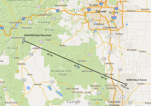
It was the Saturday of ARRL Field Day, so I planned to be out at our FD site in Black Forest. Brad and I had coordinated in advance and pretty much concluded that it would be difficult or impossible to make the contact on FM. Brad decided to take his FT-817 along with a homebrew 4-element yagi to give him 2m SSB capability. Out at the FD site, I saw that Brad was spotted on Bald Mountain (W0C/PR-019) via SOTAwatch early in the morning, so I borrowed the FD VHF station to try to work him. It was an FT-897 pushing 50 watts to a 4-element yagi up about 30 feet. I heard Brad clearly on 144.200 MHz (SSB calling frequency) and we made the contact.
I estimate that the contact was about 75 miles. I did not do a careful analysis of the terrain but the the signal had to get over the Rampart Range and quite a few other mountains to get from Black Forest to Bald Mountain. The summit of Bald Mountain is at 13,684 feet, so that certainly helps.
A few hours later, Brad showed up on the summit of Boreas Mountain (W0C/SP-030), another 13er near Breckenridge. By now, the Field Day station was in use, so I pulled out my own FT-817 and a 3-element Arrow yagi. Holding it in my hand, I pointed it towards Boreas Mountain and tuned to 144.200 MHz USB. This time Brad was even weaker but still readable, so we completed the contact.
In both cases, Brad was fair to good copy but just above the noise, I am sure that using FM would not have gotten the job done. For serious VHF work, 75 miles is not that great of a distance but we were running QRP power levels with small yagi antennas.
Brad and I are both concluding we need to encourage the use of SSB for 2m SOTA here in Colorado. It is common to end up on a high peak in the Colorado backcountry and not have enough range to reach the larger population centers. Sure there are more people active on 2m FM, but if no one is within range, it does not matter.
Congratulations to WA6MM for first activations of two more challenging summits in Colorado and thanks for 18 chaser points!
73, Bob K0NR
The post Use SSB on VHF For Better Range on SOTA Peaks appeared first on The KØNR Radio Site.
 Announcing: Oct 2015 WØTLM Technician License Class
 Ham Radio Two-Day License Class
Sat Oct 3 and Sat Oct 10 (8 AM to 5 PM) 2015
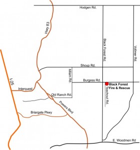
Location: Black Forest Fire Station 1, Black Forest, CO
The Technician license is your gateway to the world-wide excitement of Amateur Radio …
- Earn your ham radio Technician class radio privileges
- Pass your FCC amateur radio license exam right in class on the second day
- Multiple-choice exam, No Morse Code Required
- Live equipment demonstrations
- Learn to operate on the ham bands, 10 Meters and higher
- Learn to use the many VHF/UHF FM repeaters in Colorado
- Find out how to participate in emergency communications
There is a non-refundable $25 registration fee for the class.
In addition, students must have the required study guide and read it before attending the two-day class: HamRadioSchool.com Technician License Course $20.95
(make sure you get the most recent edition of this book, updated for the new FCC exam questions)
Advance registration is required (no later than one week before the first session, earlier is better! This class usually fills up weeks in advance.)
To register for the class, contact: Bob Witte KØNR
Email: [email protected] or Phone: 719 659-3727
Sponsored by the Tri-Lakes Monument Radio Association
For more information on amateur (ham) radio visit www.arrl.org
The post Announcing: Oct 2015 WØTLM Technician License Class appeared first on The KØNR Radio Site.
 Another June VHF Contest In the Bag
Last weekend was the ARRL June VHF Contest, my favorite ham radio event of the year. For me, this is “vhf activity weekend” when all of the vhf radio enthusiasts come out to play on the bands above 50 MHz. The sporadic-e propagation that is (almost) always present during the contest means that 6 meters will be hopping.
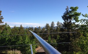 I entered in the 3-Band Single Operator category, using 6m, 2m and 70cm. My 6m rig is a Yaesu FT-950 driving a 6M5XHP Yagi antenna. For 2m and 70cm, I use a Yaesu FT-847 to drive a 2M9SSB Yagi on 2m and a similar Yagi for 70 cm. I set up portable masts at our cabin in DM78av, near Trout Creek Pass, Colorado (9600 feet).
This year, propagation seemed OK but not great. My score turned out to be about the same as last year with similar effort and same equipment, but down from previous years. 6m had sporadic-e openings very late both evenings, about the time I was ready to give up. Fortunately, I stuck with it and made quite a few contacts late into the evening.
The rovers kept things from getting too boring when 6m was not cooperating. Thanks to W3DHJ/R, ABØYM/R and WE7L/R for roving in eastern Colorado. WBØGAZ/R passed through South Park heading towards Denver and give me a few contacts. I also got a few contacts from KØCS/R and KØJJW/R. Thanks for roving!
Best DX was ZF1EJ in EK99, a new country for me on 6m.
73, Bob KØNR
K0NR June VHF Contest Summary:
 Band  QSOs  Mults
-------------------
    6:  190    83
    2:   30    13
  222:
  432:   11     6
-------------------
Total:  231    102  Total Score = 24,684
The post Another June VHF Contest In the Bag appeared first on The KØNR Radio Site.
 We Call It “Tech Field Day”
For Field Day this year, the Tri-Lakes Monument Radio Association (WØTLM) is planning a one day event that combines our Tech Day training activities with normal Field Day radio operating. This Tech Field Day will have a strong emphasis on radio education and training, including an opportunity to make contacts on the HF bands under the supervision of an experienced radio ham.
Sat June 27th, 2015 (8:00 AM to 5 PM)
Location: Black Forest Fire Station 1
11445 Teachout Road, Colorado Springs
Come to our one-day education and radio operating event and learn from informative presentations of amateur radio topics. Operate a high frequency (HF) radio station with the helpful guidance of an experienced radio ham. Learn about emergency communications and public service. Most of all, have a bunch of fun messing around with ham radio stuff!
| Time | Activity | Presenter |
| 8:00 | Setup starts | |
| 8:30 | FM Simplex and Repeaters | Bob Witte, KØNR |
| 9:30 | Operating SSB on the HF Bands | Stu Tuner, WØSTU |
| 10:30 | Construction of Dipole Antennas | Larry Kral, NØAMP |
| 11:30 | Summits On The Air (SOTA) | Steve Galchutt, WGØAT |
| 12:00 | Start Field Day Operating | |
| 13:30 | Copper pipe antennas | Al Andzik, WBØTGE |
| 14:30 | Emergency Power for Ham Radio | Mike Hoskins, WØMJH |
| 15:30 | Ask an Elmer Panel | Bob Witte KØNR and crew |
| 17:00 | End of operations – tear down |
For more information, visit the W0TLM web site.
73, Bob K0NR
The post We Call It “Tech Field Day” appeared first on The KØNR Radio Site.
 Good Operating Habits on Field Day
In preparation for ARRL Field Day, I will be doing a presentation at our radio club meeting, explaining how FD works. We have lots of newer hams, so I want to cover the basics well. I looked around on YouTube for some video of typical Field Day contacts so our members could hear what it sounds like.
This video shows Andy K5PO doing an outstanding job of operating the WR5P Noise Blankers Field Day station. Give a listen and notice how he keeps the contacts short and to the point, clearly communicating using phonetics.
73, Bob K0NR
The post Good Operating Habits on Field Day appeared first on The KØNR Radio Site.
 Can I Use My Ham Radio on Public Safety Frequencies? Updated
This is an update to one of my most popular posts.
 We have quite a few licensed radio amateurs that are members of public safety agencies, including fire departments, law enforcement agencies and search and rescue. Since they are authorized users of those public safety channels, they often ask this question:
Can I use my VHF/UHF ham radio on the fire, police or SAR channel?
It is widely known that many amateur radios can be modified to transmit outside the ham bands. The answer to this question used to be that amateur radio equipment cannot be used legally on public safety channels because it is not approved for use under Part 90 of the FCC Rules. (Part 90 covers the Private Land Mobile Radio Services.) The only option was to buy a commercial radio with Part 90 approval and a frequency range that covered the desired amateur band. Some commercial radios tune easily to the adjacent ham band but some do not. The commercial gear is usually two to three times as expensive as the amateur gear, and just as important, does not have the features and controls that ham operators expect. Usually, the commercial radios do not have a VFO and are completely channelized, typically changeable only with the required programming software.
The situation has changed dramatically in the past few years. Several wireless manufacturers in China (Wouxun, Baofeng, Anytone, etc.) have introduced low cost handheld transceivers into the US amateur market that are approved for Part 90 use. These radios offer keypad frequency entry and all of the usual features of a ham radio. It seems that these radios are a viable option for dual use: public safety and amateur radio, with some caveats.
New radios are being introduced frequently, so I won’t try to list them here. However, you might want to do a search on Wouxun, Baofeng and Anytone for the latest models. I will highlight the Anytone NSTIG-8R radio which I have been using. It seems to be a well-designed but still affordable (<$75) handheld radio. See the review by PD0AC.
Some Things to Consider When Buying These Radios
- The manufacturers offer several different radios under the same model number. Also, they are improving the radios every few months with firmware changes and feature updates. This causes confusion in the marketplace, so buy carefully.
- Make sure the vendor selling the radio indicates that the radio is approved for Part 90 use. I have seen some radios show up in the US without an FCC Part 90 label.
- Make sure the radio is specified to tune to the channels that you need.
- The 2.5-kHz tuning step is required for some public safety channels. For example, a 5-kHz frequency step can be used to select frequencies such as 155.1600 MHz and 154.2650 MHz. However, a 2.5 kHz step size is needed to select frequencies such as 155.7525 MHz. There are a number of Public Safety Interoperability Channels that require the 2.5-kHz step (e.g., VCALL10 155.7525 MHz, VCALL11 151.1375 MHz, VFIRE24 154.2725). The best thing to do for public safety use is to get a radio that tunes the 2.5-kHz steps.
- Many of these radios have two frequencies in the display, but only have one receiver, which scans back and forth between the two selected frequencies. This can be confusing when the radio locks onto a signal on one of the frequencies and ignores the other. Read the radio specifications carefully.
Recommendation
There are a number of reasonably good radios out there from various manufacturers. My favorite right now is the Anytone NSTIG-8R but I also like the Wouxun KG-UV6D. The Baofeng UV-5R continues to be popular in the amateur community as the low cost leader. However if you show up at an incident with the Baofeng, your fellow first responders will think it is a toy. Which leads to a really important point: the established commercial radio manufacturers such as Motorola, Vertex, etc. build very rugged radios. They are made for frequent, heavy use by people whose main job is putting out fires, rescuing people in trouble and dealing with criminals. These low cost radios from China are not in the same league. However, they can still serve in a less demanding physical environment while covering the Amateur Radio Service (FCC Part 97) and the Private Land Mobile Radio Services (FCC Part 90).
73, Bob K0NR
The post Can I Use My Ham Radio on Public Safety Frequencies? Updated appeared first on The KØNR Radio Site.
