Author Archive
 Social Media Noise
 A few weeks back, I had a Too Much Information meltdown, because I was being overrun with information spewing forth from various sources. To be specific, I regularly get communications from these feeds: email, SMS text, RSS feeds, Twitter, Facebook, LinkedIn and Google Plus. The amount of “stuff” that was coming in was getting out of hand so I sprang into action.
First, I asked myself, how did I get into this mess? The general trend I see is that when I first start using a particular communications tool, my goal is to connect up with as many interesting feeds as possible. For old school email, this usually means subscribing to email lists, mostly via Yahoo Groups. For Twitter, this means Following other people that have interesting tweets. As more people engage in these media, the available stuff grows rapidly. Then Google Plus comes along, which tries to improve on Twitter but is somewhat redundant with the other social media. That is, I get Google Plus postings that are the same as ones from Twitter and Facebook.
The big trap I fell into is the fear of missing something. There’s so much interesting stuff out there, I wanted to grab it all. In reality, I was still missing stuff because I was being overrun with superfluous information. Ah! This is really the classic communication problem of signal-to-noise ratio. Some of these feeds have too much noise in them so I was losing the signal!
What constitutes noise? Lots of things: Foursquare check ins, Fitbit updates, off topic posts in email lists, etc., etc. Of course, noise is in the eye of the beholder, so what is noise to me may be valuable information to you. Also, a few “noise bursts” are OK but lots of noise degrades the signal-to-noise ratio.
With signal-to-noise ratio as the primary measure, I ruthlessly slashed my collection of information sources. I dropped out of many of the Yahoo Groups (actually, I moved them to web only), I reduced the number of SMS text alerts, I pulled back on the number of Facebook friends, deleted less interesting RSS feeds. On Twitter, I started to pay attention to noisy tweets…if someone has a tendency to send noise and not so much signal, they are gone.
If I dropped you from Twitter or the other social media, please don’t take it personally. It’s just me unclogging my digital life.
Those are my thoughts…what are you doing to manage your digital life?
73, Bob K0NR
 Contest Results Are In
 In the past two weeks, the results of several ham radio contests from last summer were posted. The typical contest takes months for the official results to be finalized and I have usually forgotten about the contest by then. The more serious contesters share their results via the 3830 web site so they can get an early read on how they did relative to their peers. But you need to be patient for the official results.
In the ARRL June VHF Contest, I placed in the top ten for the new Single Operator 3 Band category. This category is restricted to 50, 144 and 432 MHz, which is a good match to my radio interests. We had good 50 MHz conditions in Colorado (relative to other parts of the country), so CO stations seemed to score well.
Speaking of Colorado, in the Colorado QSO Party I finished first in the Phone – Low Power – Single-Op category. I was actually not that pleased with my score this year (45,500), which was considerably less than my score from last year (76,464). Oh well, I will invoke the Universal Purpose of Amateur Radio and say I had a great time in the contest, regardless of the score. Thanks to the Pikes Peak Radio Amateur Association for sponsoring this event.
The ARRL Field Day results are also posted. Joyce K0JJW and I did a one transmitter (1B) operation from the cabin using the club call KVØCO, resulting in a modest score (454). We mostly made phone contacts on 20m, 15m and 6m. We had some nice sporadic-e on 50 MHz, which is always a treat. Remember, the key to a fun Field Day is: Season To Taste.
73, Bob K0NR
 Hey, My Yaesu Beeps When I Transmit!
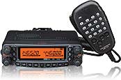 I own a variety of Yaesu ham radio transceivers and like them a lot. Except for that one little annoying feature that the FM rigs have: WIRES.
About once every two weeks, one of the local radio hams gets on the repeater with a DTMF beep at the start of every transmission. We’ve come to expect it now, so the first question to the ham is “are you by chance using a Yaesu radio?” They always say “yes” and then we talk them through the process of turning off the WIRES “feature.”
The WIRES function sends a DTMF signal at the start of every transmission for use with Yaesu’s version of internet repeater linking (which is not used much in the US). The problem is that it is very easy to bump the wrong button on your radio and accidently get it into this mode. This means that this is mostly a nuisance feature in the US.
I recently came across a way to disable this feature on your Yaesu radio so that it won’t sent the DTMF tone even if you activate it by accident. Basically, you set the WIRES tone to be empty, so nothing is transmitted if you accidentally turn on WIRES. I did not come up with this clever hack…in fact, I am not sure who put this together. (If you do, let me know and I’ll give them credit.) Take a look at this pdf file and follow the instructions to de-WIRES your radio: Turn Off Wires
73, Bob K0NR
 When All Else Fails or SHTF?
 A while back, Dan KB6NU noted the increasing number of preppers getting involved in ham radio. Preppers are people who are actively preparing for emergencies, natural disasters and disruption of social order. In our Technician license course, we’ve noticed an increase in the number of people identifying themselves as preppers.
Of course, amateur (ham) radio has a long history of emergency service and disaster preparedness. FCC Rules Part 97 says this is one of the purposes of the Amateur Radio Service: Recognition and enhancement of the value of the amateur service to the public as a voluntary noncommercial communication service, particularly with respect to providing emergency communications.
Historically, most radio amateurs approach the hobby from a technical or radio operating point of view, then find ways to apply it to emergency preparedness. The prepper tends to work the equation the other way…starting with the desire to have emergency communication capability and then working to get an amateur radio license.
Many prepper sites just give a quick overview of ham radio, positioning it with GMRS, FRS and CB radio. See Prepper Communications. Articles like this one give a more complete introduction to ham radio: The Skinny On Ham: Getting Licensed. This one, too: Every Prepper Should Be A Ham.
You may run into some creative acronyms on these prepper sites:
SHTF = ”Stuff” Hits The Fan
EOTW = End Of The World
TEOTWAWKI = The End Of The World As We Know It
YOYO – You’re On Your Own
There are web sites devoted to prepping with radio communications:
Prepared Ham
RadioSurvivalist.com
RadioMaster Reports
Many of these sites have useful information that may stretch your thinking on “being prepared.” Of course, some of these prepper sites (not the ones listed above) are a bit over the top and may have resulted from people going off their meds. Draw your own conclusions.
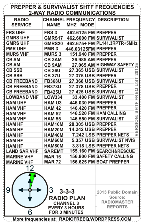
I’ve noticed a pattern of people creating prepper frequency lists, such as the one shown below. (Note that some of the ham frequencies listed do not conform to generally accepted band plans.) I can see the usefulness of having some assigned frequencies but its not clear to me how they’ll actually get used. I think the challenge for new prepper hams is to think through who they are going to communicate with and for what purpose. It’s also important to get familiar with the equipment and gain experience on the air, so when the EOTW happens you aren’t sitting there reading the radio manual.
Whether you think of emergency communications as “When All Else Fails” or when SHTF, amateur radio is a resilient communication tool.
73, Bob K0NR
Added 7 Dec 2013: I came across this video that does a good job of introducing ham radio to the prepper crowd: So you want a ham radio for emergency communications!
 Farewell, Rooster
Many of you have gotten to know Rooster and Peanut, through the videos by Steve WG0AT, the Alpha Goat. Some of you have been fortunate enough to meet the goats in person, which is always a real treat. I blogged about Steve and his goats a number of times, see this posting that highlights one of Steve’s videos.
Today we received the sad news that Rooster has died, a Silent Key in ham radio jargon.
Steve sent this message:
It’s with deep sorrow I have to make this announcement …”Rooster” goat died suddenly last night of unknown causes …his trail buddies will soon be scattering Rooster’s ashes on many SOTA peaks throughout western NA
73, Bob K0NR
 A Great Bag for the FT-817
One of my favorite rigs is the Yaesu FT-817, the QRP transceiver that covers HF through 70 cm. I use it for mountaintop VHF, including Summits On The Air (SOTA) activations.
At Pacificon, I came across this bag by AMP-3 which is custom designed for the FT-817. David KF7ETX did a great job designing this bag, which he explains in this video.
There are cheaper solutions out there but this is the best one I’ve seen.
73, Bob K0NR
 Lost Island DX Society Mysteriously Reappears
 As reported here in this blog, the Lost Island DX Society has been missing in action for over a year. Various rumors propagated around the internet and amateur radio community concerning what happened to these LIDS. Recently, the Fi-Ni Report came to life and reported that the LIDS are actively planning (or at least discussing) working the CQ Worldwide DX Contest. Of course, this is the SSB version of the contest.
No explanation has been given for the year long absence of the LIDS and the Fi-Ni Report.
73, Bob K0NR
