Author Archive
 Digital Voice at Pacificon
Last weekend, I had the privilege of attending the Pacificon amateur radio convention in Santa Clara, something I have been trying to do for several years now. It is a great event, with good technical programs and a super venue.
The most interesting presentation I saw was the one on digital voice (DV) technology by Bruce Perens K6BP. The presentation was mostly about the digital voice known as FreeDV, an open source approach to DV that uses the Codec 2 voice codec for digitally processing/compressing speech.
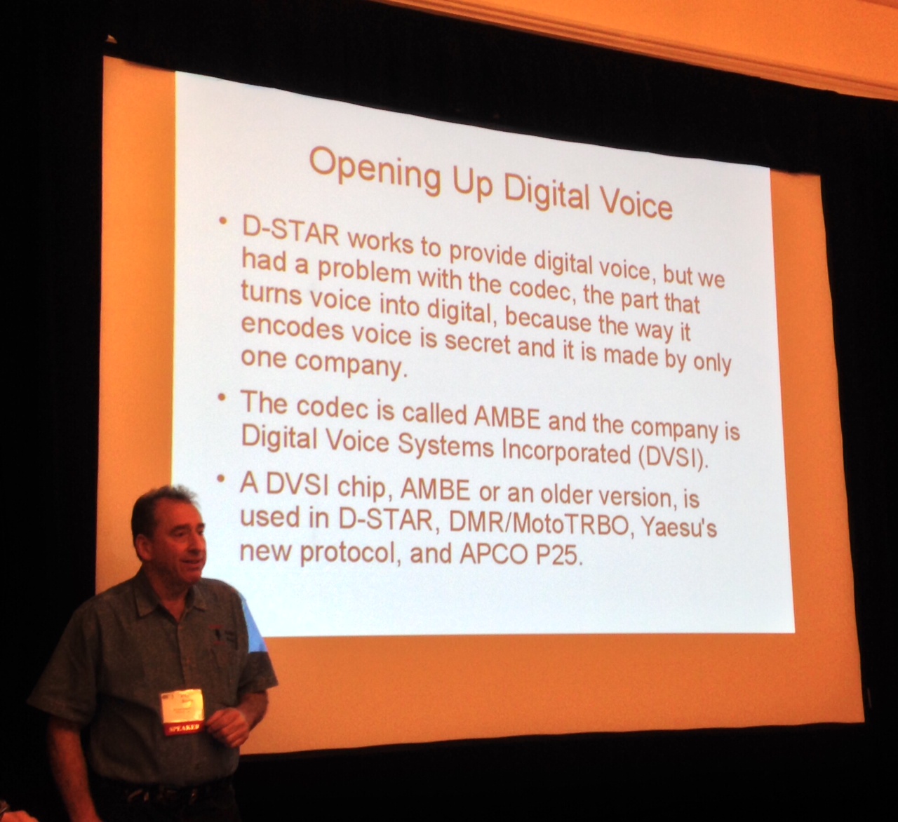
Bruce Perens K6BP talking about FreeDV
I won’t cover all of the technical details here but you can follow the links above to go deeper on the topic. The initial FreeDV efforts are focused on the HF bands, using the sound card plus computer approach to implementing DV. This is a good approach since it is a relatively easy way to adopt this technology. (Compare this to VHF/UHF where you need to solve the repeater infrastructure problem to make progress.) FreeDV operates with a bandwidth of 1.25 kHz, narrower that the standard 3 kHz or so SSB signal. FreeDV also has the benefit of degrading gracefully as the signal-to-noise ratio is decreased, with less of a digital dropoff that we see with D-STAR and other DV technologies.
Like many hams, Bruce pointed out the concerns and limitations of the proprietary AMBE chip used in D-STAR, DMR and now the new Yaesu DV system. I totally get this point and support the idea of a an open source codec. On the other hand, this work is coming more than a decade later than the creation of D-STAR. I like to refer to this phenomenon as ”our ideas are better than their products.”
Bruce introduced Chris Testa KB2BMH to talk about the “HT of the Future”. This is a handheld transceiver implemented using Software Defined Radio (SDR) and inspirations from the world of smartphones. As Bruce said, “Why isn’t your HT as smart as your smart phone?” This is similar to the Android HT idea that I blogged about a while back. See Chris’s blog and this HamRadioNow video for more information.
Another presentation that I attended was about D-STAR with several speakers, including Robin AA4RC. The innovation continues to happen in the D-STAR world with a strong theme of using Raspberry Pi computers to create D-STAR hotspots and repeaters. Robin described the “DV Pi” being developed…a DVAP-like daughter board that plugs into a Raspberry Pi. Jim Moen K6JM talked about the many ways you can implement a D-STAR Hotspot. For more info on that see his D-STAR Hotspot page.
There’s much innovation happening in the area of Digital Voice. It got me thinking about it again so I dug out my ICOM D-STAR HT and put my DVAP back on the air.
73, Bob K0NR
Better Than Duct Tape
Whenever you get a bunch of guys together to build, fix or mess with something, duct tape seems to be a universal tool. Sometimes though, one of The Guys chimes in with the comment about “well, duct tape is OK but gaffer tape is much better.” See the Wikipedia entry for Gaffer Tape.

Well, I finally listened to those guys and bought some gaffer tape on Amazon.com. I used this at a recent ham radio event to secure cables, support various masts and lash things together. You know, basic duct tape stuff.
I have to admit that this gaffer tape is really, really good. It is more cloth and less vinyl than duct tape and the adhesive does not leave a residue. Yes, it is more expensive than duct tape. Funny, how that always seems to be the case for higher quality products.
- 73, Bob K0NR
A Classic SOTA Hike: Midland Hill (W0/SP-117)
Today, Joyce K0JJW and I decided to hike Midland Hill (W0/SP-117) near Buena Vista, CO (otherwise known as “BV”) and do a SOTA activation on VHF. I call this a “classic SOTA hike” because it is a real hike that requires some exertion, a well-maintained trail to the summit and some great views at the top. By my GPS, it was 2.4 miles one way, with 1600 feet elevation gain.
This hike starts at the trailhead on the east side of BV, where a footbridge crosses the Arkansas River. The SummitPost trail description is very helpful, so be sure to check it out. I checked quite a few topo maps of the area and most of them do not show the trails accurately. I found them more confusing that helpful. I’ve included my GPS track on the map below.
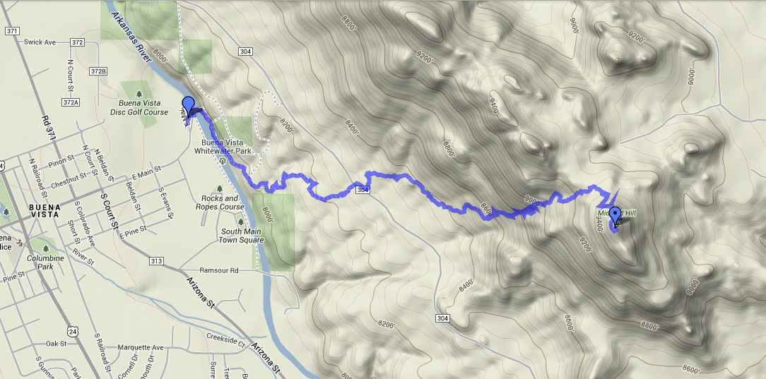
GPS track for Midland Hill
We started at the trailhead, immediately crossing the footbridge to the east side of the river. Then we followed the Midland Bike Trail which parallels the river. Very soon after the bridge, there is a trail leading off to the left (east) uphill that is tempting but we stayed on the main trail that parallels the river. At about 0.5 miles in, we crossed County Road 304 (38.843508 deg N, 106.112297 deg W) onto the clearly marked 6032 trail, which goes up to Midland Hill. Just follow the trail and do not turn onto 6032A trail as it goes off to the left.
If you are pressed for time, you can start the hike where 6032 intersects CR 304, but that only saves 0.5 miles. You’ll miss the bridge and great views of the Arkansas River.
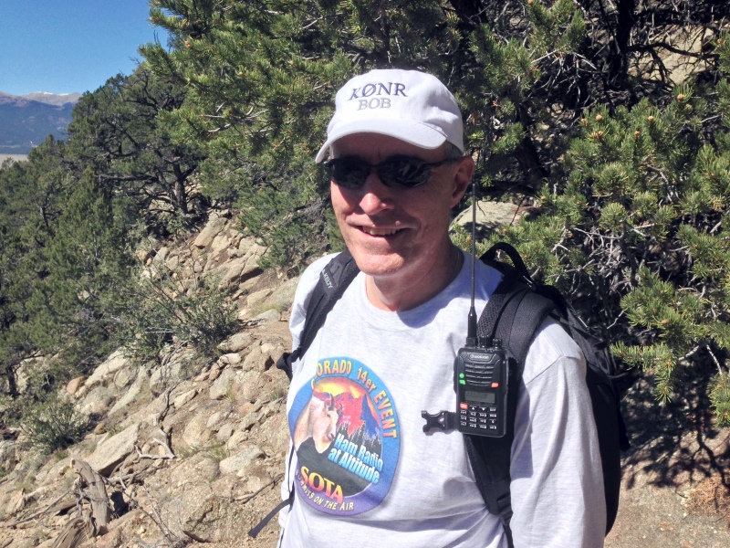
Bob K0NR on the trail
Once we reached the summit, I set up on 146.52 MHz using my VX-8G connected to the 2M Arrow Yagi. Joyce stayed back outside of the activation zone, so I worked her as soon as I made the summit. Then Walt WZ0N came up on frequency and gave me a second contact. I contacted a couple of mobile stations: Ryan KD7OHA on Highway 50 near Texas Creek and Bud NP2CT on Highway 285. Other contacts where with some of the local hams: N0OFQ near Nathrop, Jerry N0VXE and Skip W9GYA near Salida. Not bad for a Monday afternoon in the mountains. Thanks, guys, for the contacts!
Lately, some of the SOTA hikes I’ve done have involved bushwacking up the side of a steep hill to get to the summit. It was great to have a real trail this time. The 1600 vertical feet did get me huffing and puffing but that’s part of the experience. I highly recommend this summit!
73, Bob K0NR
How To Do a SOTA Activation On Pikes Peak
This post was updated on June 4, 2022, after the summit house construction was completed.
Perhaps this should be called The Slacker’s Guide to Activating Pikes Peak since I am going to describe the easy way to do a Summits On The Air (SOTA) activation on America’s Mountain. If you plan to hike up, you have my complete support but this post is not meant for you.

Pikes Peak (W0C/FR-004) is about 10 miles straight west of downtown Colorado Springs. See the Pikes Peak website for useful tourist information. At an elevation of 14,115 feet, the mountain towers over Colorado Springs and the other front-range cities. (You may see the elevation listed as 14,110 but it was revised upward in 2002 by the USGS.) This means that it has an excellent radio horizon to large populated areas. On VHF, it is possible to work stations in Kansas, Nebraska, Wyoming and New Mexico. See VHF Distance From Pikes Peak and Pikes Peak to Mt Sneffels. On HF, you’ll do even better.

Getting There
Access to the summit has three options: hike up, drive up via the Pikes Peak Highway or ride the Pikes Peak Cog Railway. Most people will probably choose the highway since the cog rail only gives you 30 to 40 minutes on the summit. (Normally, you return on the same train that takes you to the top. You can try to schedule two one-way trips but that is a challenge.)
After a few years of turmoil and construction, the summit of Pikes Peak is now back to operating normally but with some changes. The new summit house/visitors center is open and it is a beautiful new facility. The Cog Railway is also operational with brand new equipment. There is a new boardwalk that allows easy strolling on the summit and improved views near the edge of the summit.
Pikes Peak Highway
The highway is at a well-marked exit off Highway 24, west of Colorado Springs. There is a “toll” to use the highway (~$15 per person, check the Pikes Peak Highway website for the latest information and a $2 discount coupon.) Starting in 2022, you must have a reservation (2-hour window) to drive to the summit (roughly Memorial Day to Labor Day). The specifics are likely to change, so be sure to check the Drive Pikes Peak page for the latest updates.
The road is paved all of the way to the top and is usually in good shape. The only caution on driving up is that some people get freaked out by sections of the road that have steep drop-offs without guard rails. It is very safe, but some folks can’t handle it. The main caution driving down is to use low gear and stay off your brakes. There are plenty of signs reminding you to do this and during the summer there is a brake check station at Glen Cove where the rangers check the temperature of your brakes.
It takes about an hour to drive to the summit, assuming you don’t dawdle. It is best to drive up during the morning and avoid the afternoon thunderstorms.
On The Summit
The W0C Association Reference Manual (the SOTA rules for Colorado) used to suggest a “qualifying hike” of 100 vertical feet but this item has been removed from the manual. If you decide to do such a hike, I suggest you proceed down Barr Trail which is the main hiking trail coming up from the east side of the peak. Do not try to walk along the road, as the rangers will stop you. The trail starts on the east side of the summit house (towards Colorado Springs) and is marked with a sign. You have to cross over the cog rail tracks to get to it. (Please try to avoid getting run over by the train as it scares the tourists and makes a mess.)
The summit of Pikes is broad, flat and rocky, so pick out a spot away from the buildings for your SOTA adventure. There are quite a few radio transmitters on the peak so expect some interference. Since this is way above treeline, your antennas will have to be self-supporting. For VHF, giving a call on 146.52 MHz FM will usually get you a few contacts and sometimes a bit of a pileup. Be aware that on top of Pikes you are hearing everyone but they can’t always hear each other. It can get confusing. Another VHF simplex frequency worth trying is 146.58 MHz (The North America Adventure Frequency). On the HF bands, pray for good ionospheric conditions and do your normal SOTA thing.
Your body and your brain will likely be moving a little slower at 14,000 feet due to the lack of oxygen. Don’t be surprised if you have trouble deciphering and logging callsigns. Take it slow and monitor your physical condition on the peak.
Bring warm, layered clothes, even in the summer, since Pikes Peak can have arctic conditions any time of the year. Keep a close eye on the weather since thunderstorms are quite common during the summer months. Lightning is a very real danger, so abandon the peak before the storms arrive.
73, Bob K0NR
Resources
SOTAwatch web site
W0C SOTA Website
Pikes Peak Tourist Information
Pikes Peak (W0C/FR-004) SOTA Page
Pikes Peak Webcams
The post How To Do a SOTA Activation On Pikes Peak appeared first on The KØNR Radio Site.
A Soggy Mount Herman SOTA Activation (W0/FR-063)
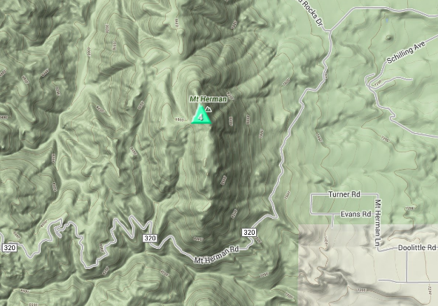
Although I’ve operated a number of VHF contests from the summit of Mount Herman, I had not yet activated it as a Summits On The Air (SOTA) peak. Mount Herman is a 9063 foot mountain just to the west of Monument, Colorado, pretty much in ”my back yard.” Steve WG0AT did the first SOTA activation of Mount Herman, back in May 2010, chronicled here in one of his famous videos. There is a sometimes rough Forest Service Road 320 that leads to the trailhead, then it’s a little more than a one mile hike to the top with 1000 feet of elevation gain. I call it a tourist hike, since it has just enough challenge to make it feel like a climb and there’s a great view at the top. At least on most days.
I was not expecting much of a view today since low rain clouds were dominating the sky. I was just hoping I would not get completely drenched by rain. The weather was definitely marginal but from my house I saw the clouds lift a bit, so I thought it was worth a try. The ARRL September VHF Contest is also this weekend, so it was a great combo opportunity: SOTA + VHF Contest.
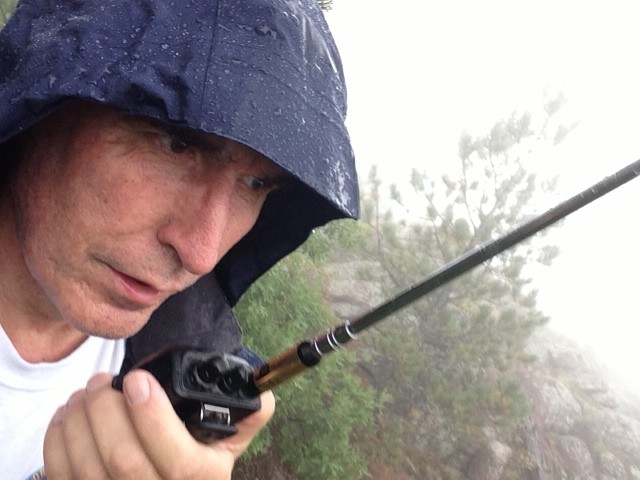
I hopped in the Jeep and quickly made the drive to the trailhead. Then I scooted on up the trail, making it to the summit in about 30 minutes. Just as I reached the summit, the rain really kicked in. I set my gear down under a tree, got out my HT, attached the 1/2-wave antenna and started calling on 147.42 MHz. I wanted to bag my four SOTA qualifying contacts in case the weather turned worse. I quickly worked Frank K0JQZ and Steve WG0AT. Then George AB0YM, operating as a rover in the VHF contest called me from grid DM78, so I worked him as well.
I had my trusty Arrow Yagi antenna with me but I didn’t want to bother with assembling it in the rain. I got out the FT-817, put a vertical antenna on it and called on 144.200 USB. I found stations working the VHF contest and completed QSOs with them: WB0RRU and K3ILC.
The rain intensified so I abandoned the summit and headed back down. All in all, it was not a great hike but I was successful in activating Mount Herman.
73, Bob K0NR
Lost Island DX Society Still Lost
 We are rapidly approaching the first anniversary of the strange disappearance of the Lost Island DX Society (LIDS) as first reported on this blog. The LIDS were last heard from via the Fi-Ni Report on September 18, 2012, reporting on the Talk Like A Pirate Contest.
Most people have given up the search for the LIDS, given the extended period of time they have been missing. One consistent rumor circulating in the DX community is that the LIDS were trying to join the Amsterdam Island DXpedition (FT5ZM) for a January 2014 activation of that island. Unfortunately, the LIDS did not realize that the island is in the middle of the Indian Ocean and not in Amsterdam. As the story goes, they had already bought nonrefundable airline tickets to Europe before they found this out. It seems that they may try to recover with a Summits On The Air (SOTA) activation, if they can find a hill high enough within walking distance of their Amsterdam hotel.
Fearing that the LIDS are simply lost somewhere in Europe, a group of hams is petitioning the White House to launch a surveillance drone to find them. As one ham said, “They’ve got them dang drones flying around spying on everyone, they might as well do some good.”
I agree completely. If nothing else, Do It For The Children.
73, Bob K0NR
Tech Day 2013 – Saturday Sept 14
 Come join us on Saturday, September 14th, 2013 (9:00 AM to 2:00 PM) at the Prairie Winds Elementary School , 790 Kings Deer Point East, Monument, CO for Tech Day 2013. Tech Day is for beginner to intermediate hams who want to learn more and take that ‘next step’ in ham radio.
Everyone is welcome, no registration is required. Just show up with your bright smiley face, ready to learn something and have fun.
Presentations
9:30 am – Getting started in QRP operating from Steve WGØAT of Rooster & Peanut fame [http://www.youtube.com/user/goathiker]
10:30 am – Mobile radio installation tips with James KDØMFO
11:30 am – Practical antennas made out of copper pipe by Al WBØTGE
12:30 pm - Ham Shack 101 - the basics of setting up a home station by Stu WØSTU
1:30 pm – Some Practical Antenna Theory – Bob KØNR
* Each presentation is approximately 20 minutes with Q&A at the end.
Live Demonstations
All day long, we’ll have these displays set up so you can get a hands on look at radio operating:
QRP operating, Flex Software Defined Radio (SDR), HF antennas, mobile radio installation
The local Boy Scout troop will be selling hotdogs and drinks in hamfest style.
Tech Day 2013 is proudly sponsored by the WØTLM Amateur Radio Club