Posts Tagged ‘hab’
 Hamfest HAB Flight – Mission Debrief
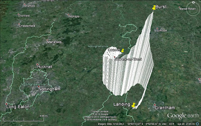
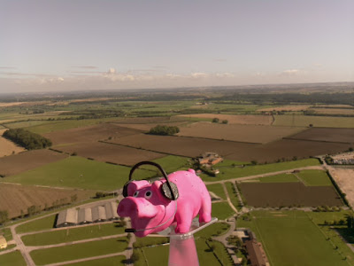
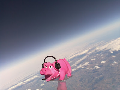
The National Hamfest high altitude balloon flew on Saturday and Pinky Pig reached a maximum altitude of nearly 26km (25,927m / 96,873 feet) as pictured above.
The flight originally planned for Friday had to be postponed due to wind direction and restrictions but I had sort approval for both days and was able to fly on Saturday. The conditions were perfect on launch day, clear blue sky with little cloud and almost no wind. Flight prediction put it landing around 25km away.
Both payload trackers worked flawlessly, PINKY the high speed RTTY successfully sent SSDV as well as telemetry and the backup tracker PIGLET sent the slow speed RTTY telemetry. Trackers from all over the UK as well as France, Holland and Poland received data and uploaded data to the UKHAS website.
The received SSDV images can be seen at http://ssdv.habhub.org/PINKY
The flight path can be seen below
The flight can be seen visualised in Google Earth below and while the 26km altitude was impressive it was around 4km less than I'd planned.
The launch certainly created a great deal of interest at the Hamfest, on the Friday we setup the club tent for South Kesteven ARS with a tracking station and demonstrated the payloads to interested visitors. Stewart (M0SDM) used his Land Rover with a push up mast for a pair of collinear X-50s so we could receive and decode. The mast and the Land Rover generated just as much interest.
On the Saturday I was assisted by my brother David (M6GTD) and just before noon began filling the balloon watched by a large crowd, as can be seen on Dave's (M0TAZ) blog http://m0taz.co.uk/2015/09/national-hamfest-2015/
 |
| Picture by Dave M0TAZ |
Once filled to give the correct lift I sealed it off and checked everything was working then without a breath of wind slowly let the balloon rise, taking the weight of the payloads and once I was sure there were no aircraft flying nearby I let her go. The sky was clear and the balloon went up near vertically and could be seen for quite a long time as it ascended. Representatives of the RSGB and RadCom were in attendance to take photos and did a quick interview.
The tracking station was then full of people as the telemetry and pictures started to be received. It was great to see the huge interest in the balloon.
As the balloon started to near the planned maximum altitude I began to get ready to set off to recover it then suddenly I was told it had burst sooner than expected. I got a hurry up at which point the laptop and mobile connection decided to stop working! However I knew where to head off with my poor brother trying to sort it out as I drove.
Stewart telephoned and gave me directions of where the live prediction and tracking had put the landing spot. My wife also set off from home to come and assist. In the car we were receiving a signal but were struggling to decode and couldn't get on the internet to check the tracking.
I eventually pulled up near the landing zone, while trying to decode the weak signal another car pulled up with two radio amateurs who had been tracking the balloon. I was a little preoccupied and they eventually said they were off and wished us luck. I then realised we were the wrong side of the hill and turned around and drove up to the top and the signal strength increased.
Stewart had phoned to tell me to find the Viking way footpath, as we reached ground zero we saw the other amateurs car and they were setting off down the footpath! It was my flight I wanted to be the first to find it!
My wife then pulled up and was about to set off after them! Then I started getting successful decodes! With the new landing position in the GPS my wife raced off in hot pursuit as I sorted out the car and then followed her with my brother. It was a reasonable walk of around 800m and as we got near it became apparent the other team had been using the online tracker and had only got the last received position which had been sent from around 254m altitude. However the payload was still transmitting strongly and we were decoding it and it was reporting it was in fact at 115m altitude - they were therefore several hundred meters in the wrong direction.
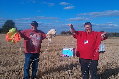
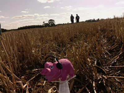
Our accurate location gave us the edge and a quick hop up a bank into a stubble field and a 200m jog my brother spotted the parachute... we had found Pinky and Piglet and got there first!
I was surprised to find most of the balloon still attached, it hadn't so much burst as split in a single tear
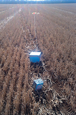
The payloads had no damage, other than the antenna being bent by the landing
PIGLET had landed as planned and tested, I had put the battery pack at the top of the box the top heavy center of gravity causing it to roll on landing so the antenna would be upright. It was in a perfect orientation hence the strong signal.
The other chase team turned up and congratulated us then left... my apologies but I was in my own little happy place to be sociable. We then then had the obligatory team photograph before setting back to the Hamfest.
It has been an excellent experience and adventure. The pictures are better than I could have hoped for! Thanks to my understanding wife, my brother David and Stewart for setting up the antennas for the tracking station and manning it on his own while we went off to recover the payload.
Thanks to the organisers of the National Hamfest and Graham Boor (G8NWC) for asking me to do the flight and helping fund the venture and I hope it succeeded in publicising the event and the hobby.
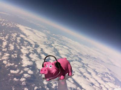
I have now downloaded all the photographs from the onboard camera and they can been in my Flickr album at https://www.flickr.com/photos/nerdsville/sets/72157658732989849
Updated - I realised I didn't put the actual landing position on this post, so here it is
 Hamfest HAB Flight – Mission Debrief
The National Hamfest high altitude balloon flew on Saturday and Pinky Pig reached a maximum altitude of nearly 26km (25,927m / 96,873 feet) as pictured above.
The flight originally planned for Friday had to be postponed due to wind direction and restrictions but I had sort approval for both days and was able to fly on Saturday. The conditions were perfect on launch day, clear blue sky with little cloud and almost no wind. Flight prediction put it landing around 25km away.
Both payload trackers worked flawlessly, PINKY the high speed RTTY successfully sent SSDV as well as telemetry and the backup tracker PIGLET sent the slow speed RTTY telemetry. Trackers from all over the UK as well as France, Holland and Poland received data and uploaded data to the UKHAS website.
The received SSDV images can be seen at http://ssdv.habhub.org/PINKY
The flight path can be seen below
The flight can be seen visualised in Google Earth below and while the 26km altitude was impressive it was around 4km less than I'd planned.
The launch certainly created a great deal of interest at the Hamfest, on the Friday we setup the club tent for South Kesteven ARS with a tracking station and demonstrated the payloads to interested visitors. Stewart (M0SDM) used his Land Rover with a push up mast for a pair of collinear X-50s so we could receive and decode. The mast and the Land Rover generated just as much interest.
On the Saturday I was assisted by my brother David (M6GTD) and just before noon began filling the balloon watched by a large crowd, as can be seen on Dave's (M0TAZ) blog http://m0taz.co.uk/2015/09/national-hamfest-2015/
 |
| Picture by Dave M0TAZ |
Once filled to give the correct lift I sealed it off and checked everything was working then without a breath of wind slowly let the balloon rise, taking the weight of the payloads and once I was sure there were no aircraft flying nearby I let her go. The sky was clear and the balloon went up near vertically and could be seen for quite a long time as it ascended. Representatives of the RSGB and RadCom were in attendance to take photos and did a quick interview.
The tracking station was then full of people as the telemetry and pictures started to be received. It was great to see the huge interest in the balloon.
As the balloon started to near the planned maximum altitude I began to get ready to set off to recover it then suddenly I was told it had burst sooner than expected. I got a hurry up at which point the laptop and mobile connection decided to stop working! However I knew where to head off with my poor brother trying to sort it out as I drove.
Stewart telephoned and gave me directions of where the live prediction and tracking had put the landing spot. My wife also set off from home to come and assist. In the car we were receiving a signal but were struggling to decode and couldn't get on the internet to check the tracking.
I eventually pulled up near the landing zone, while trying to decode the weak signal another car pulled up with two radio amateurs who had been tracking the balloon. I was a little preoccupied and they eventually said they were off and wished us luck. I then realised we were the wrong side of the hill and turned around and drove up to the top and the signal strength increased.
Stewart had phoned to tell me to find the Viking way footpath, as we reached ground zero we saw the other amateurs car and they were setting off down the footpath! It was my flight I wanted to be the first to find it!
My wife then pulled up and was about to set off after them! Then I started getting successful decodes! With the new landing position in the GPS my wife raced off in hot pursuit as I sorted out the car and then followed her with my brother. It was a reasonable walk of around 800m and as we got near it became apparent the other team had been using the online tracker and had only got the last received position which had been sent from around 254m altitude. However the payload was still transmitting strongly and we were decoding it and it was reporting it was in fact at 115m altitude - they were therefore several hundred meters in the wrong direction.
Our accurate location gave us the edge and a quick hop up a bank into a stubble field and a 200m jog my brother spotted the parachute... we had found Pinky and Piglet and got there first!
I was surprised to find most of the balloon still attached, it hadn't so much burst as split in a single tear
The payloads had no damage, other than the antenna being bent by the landing
PIGLET had landed as planned and tested, I had put the battery pack at the top of the box the top heavy center of gravity causing it to roll on landing so the antenna would be upright. It was in a perfect orientation hence the strong signal.
The other chase team turned up and congratulated us then left... my apologies but I was in my own little happy place to be sociable. We then then had the obligatory team photograph before setting back to the Hamfest.
It has been an excellent experience and adventure. The pictures are better than I could have hoped for! Thanks to my understanding wife, my brother David and Stewart for setting up the antennas for the tracking station and manning it on his own while we went off to recover the payload.
Thanks to the organisers of the National Hamfest and Graham Boor (G8NWC) for asking me to do the flight and helping fund the venture and I hope it succeeded in publicising the event and the hobby.
I have now downloaded all the photographs from the onboard camera and they can been in my Flickr album at https://www.flickr.com/photos/nerdsville/sets/72157658732989849
Updated - I realised I didn't put the actual landing position on this post, so here it is
 Hamfest HAB Launch likely to be postponed to Saturday
Given the latest flight path prediction, weather forecast and approval restrictions I will unfortunately have to likely postpone the National Hamfest high altitude balloon till Saturday.
The forecast for tomorrow is strong gusty winds at ground level which isn't ideal for launching, but that is the least of the issues.
The current flight predictions for tomorrow are not good. The prediction model used is accurate and for the size of balloon I have and the amount of helium at my disposal even a maximum fill giving the maximum ascent rate and assuming the calculated decent rate for the parachute it is still putting the likely landing right on the coast. Earlier in the week the landing wasn't quite as marginal but as the model's data set have been updated it has drifted further eastward, it is odds on it will actually land out to sea.
However the real show stopper was when I received the CAA approval for the launch this morning. They have put a restriction not permitting a launch if the balloon and payload is likely to go on a North Easterly or Easterly path that could interfere with operations on local military airfields.
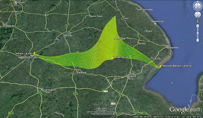
This is the predicted flight path, generated by the CUSG Landing predictor at predict.habhub.org and the flight path currently goes directly over RAF Cranwell but not at a high enough altitude.
Saturday is forecast to be a much calmer day with a predicted path as shown below
There would be no issues with the airfields for that flight path and has the advantage of going almost straight up and landing close by.
Apologies to those wanting to track on Friday, but the situation is out of my control and I would be foolhardy to ignore the prediction and it is very unlikely it will change significantly to allow a flight tomorrow so I hope you can all track on Saturday. I will still be at the Hamfest tomorrow with the equipment if you want to know more about what it is all about.
The forecast for tomorrow is strong gusty winds at ground level which isn't ideal for launching, but that is the least of the issues.
The current flight predictions for tomorrow are not good. The prediction model used is accurate and for the size of balloon I have and the amount of helium at my disposal even a maximum fill giving the maximum ascent rate and assuming the calculated decent rate for the parachute it is still putting the likely landing right on the coast. Earlier in the week the landing wasn't quite as marginal but as the model's data set have been updated it has drifted further eastward, it is odds on it will actually land out to sea.
However the real show stopper was when I received the CAA approval for the launch this morning. They have put a restriction not permitting a launch if the balloon and payload is likely to go on a North Easterly or Easterly path that could interfere with operations on local military airfields.
This is the predicted flight path, generated by the CUSG Landing predictor at predict.habhub.org and the flight path currently goes directly over RAF Cranwell but not at a high enough altitude.
 |
| Flight prediction for Friday |
 |
| Flight prediction for Saturday |
There would be no issues with the airfields for that flight path and has the advantage of going almost straight up and landing close by.
Apologies to those wanting to track on Friday, but the situation is out of my control and I would be foolhardy to ignore the prediction and it is very unlikely it will change significantly to allow a flight tomorrow so I hope you can all track on Saturday. I will still be at the Hamfest tomorrow with the equipment if you want to know more about what it is all about.
 Hamfest HAB Launch likely to be postponed to Saturday
Given the latest flight path prediction, weather forecast and approval restrictions I will unfortunately have to likely postpone the National Hamfest high altitude balloon till Saturday.
The forecast for tomorrow is strong gusty winds at ground level which isn't ideal for launching, but that is the least of the issues.
The current flight predictions for tomorrow are not good. The prediction model used is accurate and for the size of balloon I have and the amount of helium at my disposal even a maximum fill giving the maximum ascent rate and assuming the calculated decent rate for the parachute it is still putting the likely landing right on the coast. Earlier in the week the landing wasn't quite as marginal but as the model's data set have been updated it has drifted further eastward, it is odds on it will actually land out to sea.
However the real show stopper was when I received the CAA approval for the launch this morning. They have put a restriction not permitting a launch if the balloon and payload is likely to go on a North Easterly or Easterly path that could interfere with operations on local military airfields.
This is the predicted flight path, generated by the CUSG Landing predictor at predict.habhub.org and the flight path currently goes directly over RAF Cranwell but not at a high enough altitude.
Saturday is forecast to be a much calmer day with a predicted path as shown below
There would be no issues with the airfields for that flight path and has the advantage of going almost straight up and landing close by.
Apologies to those wanting to track on Friday, but the situation is out of my control and I would be foolhardy to ignore the prediction and it is very unlikely it will change significantly to allow a flight tomorrow so I hope you can all track on Saturday. I will still be at the Hamfest tomorrow with the equipment if you want to know more about what it is all about.
The forecast for tomorrow is strong gusty winds at ground level which isn't ideal for launching, but that is the least of the issues.
The current flight predictions for tomorrow are not good. The prediction model used is accurate and for the size of balloon I have and the amount of helium at my disposal even a maximum fill giving the maximum ascent rate and assuming the calculated decent rate for the parachute it is still putting the likely landing right on the coast. Earlier in the week the landing wasn't quite as marginal but as the model's data set have been updated it has drifted further eastward, it is odds on it will actually land out to sea.
However the real show stopper was when I received the CAA approval for the launch this morning. They have put a restriction not permitting a launch if the balloon and payload is likely to go on a North Easterly or Easterly path that could interfere with operations on local military airfields.
This is the predicted flight path, generated by the CUSG Landing predictor at predict.habhub.org and the flight path currently goes directly over RAF Cranwell but not at a high enough altitude.
 |
| Flight prediction for Friday |
 |
| Flight prediction for Saturday |
There would be no issues with the airfields for that flight path and has the advantage of going almost straight up and landing close by.
Apologies to those wanting to track on Friday, but the situation is out of my control and I would be foolhardy to ignore the prediction and it is very unlikely it will change significantly to allow a flight tomorrow so I hope you can all track on Saturday. I will still be at the Hamfest tomorrow with the equipment if you want to know more about what it is all about.
 Hamfest HAB – Pre Launch Update
Not long now! Just three days left till the National Hamfest and hopefully the launch of my second high altitude balloon.
Balloon, parachute and helium have all been purchased and payloads have under gone final testing and have been put to one side ready for the flight which should hopefully be around 12pm on Friday 25th September.
The SSDV payload callsign PINKY will transmit on 434.575MHz USB RTTY 300 baud 880Hz shift ASCII-8 no parity 2 stop bits.
the backup telemetry tracker callsign PIGLET will transmit 434.150MHz USB RTTY 50 baud 380Hz shift ASCII-7 no parity 2 stop bits
They will transmit using the UKHAS telemetry protocol and can be tracked on tracker.habhub.org for information on how to receive and upload data to the tracking system visit the UKHAS wiki some information and useful links have been collated on the AMSAT-UK website
I was hoping to also transmit using the LoRa system, using the callsign PERKY. The transmitter had been successfully tested but a last minute gremlin has struck and it stopped working this weekend, I have been unable to locate the fault and suspect it is the actual module and with time being short have all but given up getting it working. If I do get it working it will be on 434.450MHz in Mode 1
I have already detailed the PIGLET payload in an earlier post. The PINKY/PERKY payload is constructed on strip board and was originally meant to to be a prototype, hence the rubbish layout. I had planned to build a better laid out version but the tight time scale, stresses and demands of work, commitments with the radio club not to mention nursing the wife as she recovers from a major operation scuppered that plan. Being pragmatic I decided it didn't need to be work of art to work! I have secured all the connections with hot glue and it has been drop tested several times.
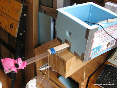
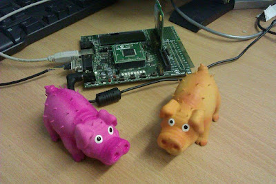
"Pinky" pig will be the passenger on the day, donning his fetching headset. Getting him in the right position for the camera was tricky.
I am still waiting for the CAA approval, should hopefully get it soon. I have put in a request for both days of the Hamfest just in case, the latest prediction at predict.habhub.org shows if I get the fill right I might just escape a watery landing on Friday, however Saturday looks more promising at the moment - also the forecast for Friday at the moment also has strong gusty surface winds, which could make the launch problematic. I am still planning for Friday since conditions and predictions do change.
I and other members of South Kesteven ARS will be in attendance with a tracker station on the day, so please introduce yourself and perhaps join the club?
Please don't mention anything to do with other pigs in the news..
Balloon, parachute and helium have all been purchased and payloads have under gone final testing and have been put to one side ready for the flight which should hopefully be around 12pm on Friday 25th September.
The SSDV payload callsign PINKY will transmit on 434.575MHz USB RTTY 300 baud 880Hz shift ASCII-8 no parity 2 stop bits.
 |
| SSDV Test image |
They will transmit using the UKHAS telemetry protocol and can be tracked on tracker.habhub.org for information on how to receive and upload data to the tracking system visit the UKHAS wiki some information and useful links have been collated on the AMSAT-UK website
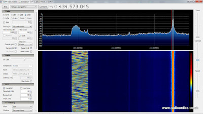
I was hoping to also transmit using the LoRa system, using the callsign PERKY. The transmitter had been successfully tested but a last minute gremlin has struck and it stopped working this weekend, I have been unable to locate the fault and suspect it is the actual module and with time being short have all but given up getting it working. If I do get it working it will be on 434.450MHz in Mode 1
 |
| PERKY seen working on SDR |
 |
| PINKY & PERKY tracker |
"Pinky" pig will be the passenger on the day, donning his fetching headset. Getting him in the right position for the camera was tricky.
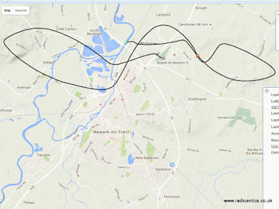
I am still waiting for the CAA approval, should hopefully get it soon. I have put in a request for both days of the Hamfest just in case, the latest prediction at predict.habhub.org shows if I get the fill right I might just escape a watery landing on Friday, however Saturday looks more promising at the moment - also the forecast for Friday at the moment also has strong gusty surface winds, which could make the launch problematic. I am still planning for Friday since conditions and predictions do change.
 |
| Friday prediction as of 22/09/2015 |
 |
| Saturday prediction as of 22/09/2015 |
Please don't mention anything to do with other pigs in the news..
 Hamfest HAB – Pre Launch Update
Not long now! Just three days left till the National Hamfest and hopefully the launch of my second high altitude balloon.
Balloon, parachute and helium have all been purchased and payloads have under gone final testing and have been put to one side ready for the flight which should hopefully be around 12pm on Friday 25th September.
The SSDV payload callsign PINKY will transmit on 434.575MHz USB RTTY 300 baud 880Hz shift ASCII-8 no parity 2 stop bits.
the backup telemetry tracker callsign PIGLET will transmit 434.150MHz USB RTTY 50 baud 380Hz shift ASCII-7 no parity 2 stop bits
They will transmit using the UKHAS telemetry protocol and can be tracked on tracker.habhub.org for information on how to receive and upload data to the tracking system visit the UKHAS wiki some information and useful links have been collated on the AMSAT-UK website
I was hoping to also transmit using the LoRa system, using the callsign PERKY. The transmitter had been successfully tested but a last minute gremlin has struck and it stopped working this weekend, I have been unable to locate the fault and suspect it is the actual module and with time being short have all but given up getting it working. If I do get it working it will be on 434.450MHz in Mode 1
I have already detailed the PIGLET payload in an earlier post. The PINKY/PERKY payload is constructed on strip board and was originally meant to to be a prototype, hence the rubbish layout. I had planned to build a better laid out version but the tight time scale, stresses and demands of work, commitments with the radio club not to mention nursing the wife as she recovers from a major operation scuppered that plan. Being pragmatic I decided it didn't need to be work of art to work! I have secured all the connections with hot glue and it has been drop tested several times.
"Pinky" pig will be the passenger on the day, donning his fetching headset. Getting him in the right position for the camera was tricky.
I am still waiting for the CAA approval, should hopefully get it soon. I have put in a request for both days of the Hamfest just in case, the latest prediction at predict.habhub.org shows if I get the fill right I might just escape a watery landing on Friday, however Saturday looks more promising at the moment - also the forecast for Friday at the moment also has strong gusty surface winds, which could make the launch problematic. I am still planning for Friday since conditions and predictions do change.
I and other members of South Kesteven ARS will be in attendance with a tracker station on the day, so please introduce yourself and perhaps join the club?
Please don't mention anything to do with other pigs in the news..
Balloon, parachute and helium have all been purchased and payloads have under gone final testing and have been put to one side ready for the flight which should hopefully be around 12pm on Friday 25th September.
The SSDV payload callsign PINKY will transmit on 434.575MHz USB RTTY 300 baud 880Hz shift ASCII-8 no parity 2 stop bits.
 |
| SSDV Test image |
They will transmit using the UKHAS telemetry protocol and can be tracked on tracker.habhub.org for information on how to receive and upload data to the tracking system visit the UKHAS wiki some information and useful links have been collated on the AMSAT-UK website
I was hoping to also transmit using the LoRa system, using the callsign PERKY. The transmitter had been successfully tested but a last minute gremlin has struck and it stopped working this weekend, I have been unable to locate the fault and suspect it is the actual module and with time being short have all but given up getting it working. If I do get it working it will be on 434.450MHz in Mode 1
 |
| PERKY seen working on SDR |
 |
| PINKY & PERKY tracker |
"Pinky" pig will be the passenger on the day, donning his fetching headset. Getting him in the right position for the camera was tricky.
I am still waiting for the CAA approval, should hopefully get it soon. I have put in a request for both days of the Hamfest just in case, the latest prediction at predict.habhub.org shows if I get the fill right I might just escape a watery landing on Friday, however Saturday looks more promising at the moment - also the forecast for Friday at the moment also has strong gusty surface winds, which could make the launch problematic. I am still planning for Friday since conditions and predictions do change.
 |
| Friday prediction as of 22/09/2015 |
 |
| Saturday prediction as of 22/09/2015 |
Please don't mention anything to do with other pigs in the news..
 Hamfest HAB – "Pigs In Space" Preparations
Already a week into September and not long now till the National Hamfest where I and the South Kesteven ARS are launching a high altitude balloon launch subject to CAA approval. The documents have been submitted so just waiting for the nod.
The balloon and parachute have been purchased from Steve Randall (G8KHW) at Random Engineering, using the same size as I did for the Eggsplorer-1
I had joked about sending some "Ham into space" on this flight but following the smelly end to Eggsplorer-1 have opted to play it safe and avoid food! Instead will be sending up a toy pig (well a small squeaky dog toy)
Similar to the Eggsplorer-1 the main tracker will be a Raspberry Pi fitted with a camera and two transmitters.
The tracker is based on the "Pi In The Sky" code base/design by Dave Akerman (M0RPI) and Anthony Stirk (M0UPU) with some modifications since I am building on simple strip board using a different GPS module/interface and omitting any power supply monitoring.
On the Eggsplorer I used an old Pi Model B but was forced to butcher it to reduce the power demand by desoldering the network/usb chip. This time I am using a Model A+ which is smaller/lighter and has a much reduced power demand and with the locking micro-SD card socket will hopefully prevent a repeat of Eggsplorer-1's failure mode.
PINKY & PERKY are progressing well, just waiting delivery of some strip board and they should be completed in the next day or so.
PINKY will be 300-Baud RTTY, sending telemetry along with SSDV image packets using the UKHAS format.
PERKY will be using one of the LoRa modules again sending telemetry and SSDV but with greater resolution and speed, but will require a LoRa receiver/gateway (see Dave Akerman's website).
While the SSDV is attractive to tracker enthusiasts the high speed RTTY is more difficult to receive, so I will be flying a secondary 'backup' tracker. The use of a backup proved invaluable on the Eggsplorer when the main tracker failed.
PIGLET will be a 50-baud RTTY transmission with telemetry and should prove easier to receive.
I finished PIGLET at the weekend
Again built on strip board it is based around the ATMEL ATMega128 micro-controller using the Arduino system with a number of off the shelf modules connected to it.
It has one of the GY-GPS6MV2 GPS modules I blogged about last year feeding into the UART. The NTX-2B transmitter (frequency agile version from Hab Supplies) and a I2C BMP180 pressure/sensor module (not visible as mounted to measure external conditions) It also has a small boost converter to supply 5V and extract all the available power it can from the 3-AA lithium battery pack.
One change compared to the EGG1 tracker is to use a PWM output from the Arduino to generate the RTTY tones rather than a register voltage divider (guide here) which seems to give a cleaner signal.
The antenna is simply copper wire making a 1/4 wave ground plane. The 'box' are some layers of styrofoam glued together with UHU-Por with duct tape, some straws and beads for safety. Just needs the batteries fitting and the lid fixing with more duct tape and PIGLET is ready to fly.
Full details of frequencies will be posted nearer the time.


